The Junction Photo
  • The area around the junction of the Tumut &  Murrumbidgee rivers was first farmed sometime between 1825 & 1829. 

  • The scene in the photo is the present day view when approaching the property  "Mingay" from the north (from the Hume Highway).

  • This topography is what Charles Sturt saw when he approached Mingay in November 1829, as he began his epic journey of discovery down the Murrumbidgee (and back).

  • In the photo, the Murrumbidgee River flows from left to right (that is - to the west). The line of trees at the base of the hills and beyond the river flats, mark the position of the river.

  • The Tumut River flows towards us out of the valley that can be seen straight ahead of us.

  • There is of course a vast difference in the vegetation we see today and that seen by Charles Sturt in the late spring of 1829. There were no introduced grasses, no clovers and no deciduous trees for him to see.

  • In 1829 the soil lacked phosphorues and the addition of superphosphate about a hundred years later transformed this scene for us. 
Tumut
History
email me
Mail:- Tumut History, PO Box 132, Tumut, NSW 2720, Australia
"Information is our only purpose; that accomplished, we shall consider that we have done our duty."  Reference
Map
Newspaper
Menu
From

  • William Warby (the first settler at Mingay) was the eldest son of John Warby

  • Initially, John Warby farmed land near Prospect Creek which has Prospect Hill as its source (west of Parramatta).

  • After the Colony's lost cattle were found in 1795 at Cowpastures (now Camden), John Warby was charged with the job of looking after them. He also conducted tours to the site from his home.

  • Eventually, the track forged by John from his home to the cowpastures was surveyed and become known as the "Cowpastures Road". Today, the northern half of it is still known by that name.

  • The southern part of Warby's track is now part of the what is called the "Camden Valley Way" (although at one time it was the known as the "Hume Highway"). It still crosses the Nepean River at Cowpastures Bridge, just before entering Camden.

Major Error Alerts
1.
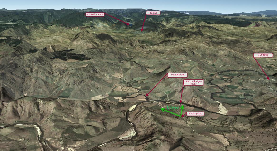
Many old newspapers report the first settler at Mingay (at the junction of the Murrumbidgee and Tumut Rivers) as being Benjamin Warby.

However, this information is the perpetuation of a mistake made by James Gormly in a widely reported speech he made in 1906 .

(No record has been found showing James as attempting to correct his mistake).

Ben Warby was a younger brother of the real first settler - William Warby.

After William was convicted of receiving stolen cattle, all the goods and stock on the land were seized by the authorities and sold at auction.

Even the sale papers that show Mingay was sold to Benjamin by William are doubtful as the "sale" of the land may have been found to be fraudulent. 

2.
On the south bank of the Muttama creek there is a plaque showing Ben Warby as the original settler on Mingay in 1825.

a. One book claims a Benjimin Warby was the original settler - at Mingay and his son (Ben) was the original settler accross the Murrumbidgee from Mningay, at Darbalara..

b. Although a person called Warby was operating an established farm at Mingay when Charles Sturt visited him in November 1829, it seems improbable that he was living there as early as 1825 - because:-

  • The exploration party headed by Hume and Hovell did not return to Sydney until early 1825.

  • On the 20th of May 1825 William Warby was in Sydney giving evidence in a Supreme Criminal Court hearing over the death of Lucy Clegg in 5th February 1825 at Liverpool.

  • On the 21st of November 1825 William was granted land at Towrang (north of Goulburn) - although, it is not clear if he actually lived on this land.

3.
  • The truth may never be known because these claims to land were not legal and therefore not officillay documentesd.
Prospect Reservoir

Today, John Warby's Farm is bisected by Davis Road just below the dam wall of Prospect Reservoir.

Recent archaeological finds in the dam appear to date from the time when the Warby Family lived nearby.

https://www.flickr.com/photos/scaonline/sets/72157644773717332/


Besides being a Convict and a Farmer, John Warby was also an Explorer, Government Heardsman, Constable, and the Governor's Guide. He even helped to catch a bushranger and negotiated with the aboriginal people.


Search for Warby.

Use the "Search" facility of this website to find over 75 articles containg the name "Warby".

It is not known if the world water speed record holder (Ken Warby) is related to the pioneer Warby famly.


John Warby died on 12 June 1851

John died at Spring Valley near Campbelltown
John's wife Sarah, lived on until 19 October 1869.

At the time of John Warby's death there were eleven surviving children of a claimed 23 births by his wife, Sarah. (One even survived to see the 20th century.)
  • William (1801-1885),
  • Elizabeth (1802-1984),
  • Benjamin (1805-1880),
  • Jane (1806-1876),
  • Sarah (1806-1893),
  • Charles Cable (1810-1876),
  • Mary Ann (1813-1904),
  • Robert George (1814-1853),
  • Eliza (1815-1896),
  • James (1817-1899),
  • Joseph (1818-1899).

At least three of his children who predeceased him are known:
  • Edward (1800-1804),
  • John (1803-1826),
  • Richard (1821- died as an infant).


The pioneering track that arrived at
the mouth of the Tumut River in the 1820s began in 1795 with a father, John Warby of Prospect and ended 400 km away when John's son, William Warby settled on Mingay.
In essence, that track is still in use today - it is now called the Hume Highway.
index sitemap advanced
search engine by freefind